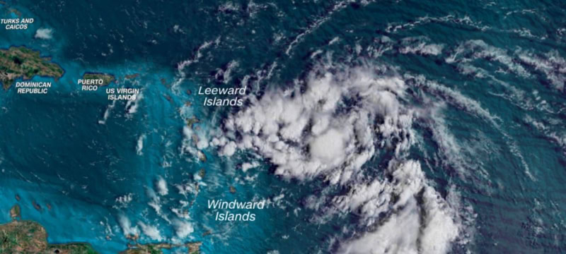
Tropical Storm Ernesto is intensifying as it impacts the northern Caribbean Islands, bringing heavy rain, strong winds, and rough seas to the Virgin Islands and Puerto Rico. Hurricane watches are in effect for the US and British Virgin Islands, Vieques, and Culebra, with forecasts suggesting Ernesto could become a hurricane by tonight or early Wednesday due to warm ocean waters.
The storm’s maximum sustained winds increased by 25 mph to 65 mph in just 12 hours, approaching the threshold for rapid intensification. Ernesto’s center moved over the Virgin Islands after passing near Guadeloupe, continuing its path through the region since forming on Monday.
Read more: Mpox Outbreak in Africa Declared Public Health Emergency
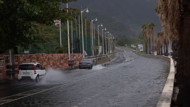
A flash flood warning has been issued for St. Croix in the US Virgin Islands, with heavy rain causing potential flooding. The National Weather Service reports that between 1 and 2 inches of rain have fallen, with an additional 2 to 3 inches possible.
Tropical storm-force winds from Ernesto extend up to 115 miles from its center, bringing gusty conditions to a broad area. A gust of 65 mph was recorded at Saint Barthélemy (St. Bart’s) when Ernesto was about 100 miles away.
The storm’s wind and rain are expected to affect more regions overnight Tuesday into Wednesday. Tropical storm warnings are in place for Puerto Rico and the Leeward Islands, including the US and British Virgin Islands. Ernesto’s strong winds could damage structures, topple trees, and disrupt power lines.
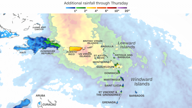
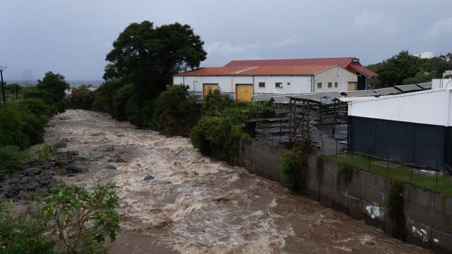
Heavy rainfall is a major threat this week, with significant potential for flooding. Rainfall will continue in the Leeward Islands through Tuesday night and extend to the US and British Virgin Islands by Tuesday evening and Puerto Rico by nightfall. Total rainfall could reach 4 to 6 inches widely, with up to 10 inches possible in Puerto Rico, increasing the risk of flash flooding and mudslides, particularly in elevated areas.
Tropical storm-force winds from Ernesto will continue to affect areas within its path through at least Wednesday night, bringing dangerous seas and up to 3 feet of storm surge to many islands in the region.
The combination of rain and wind poses a threat to Puerto Rico’s already vulnerable electrical infrastructure. Officials have activated the National Guard, canceled public school classes, and warned of widespread power outages due to the fragile state of the power grid, still under repair since Hurricane Maria in 2017.
Juan Saca of Luma Energy acknowledged the situation’s gravity, while FEMA’s Jaclyn Rothenberg emphasized the importance of finalizing preparations. Rothenberg noted that while residents of Puerto Rico and the US Virgin Islands are experienced with storms, travelers visiting the islands this summer also need to be aware of the situation.
With potential power outages, it’s crucial to stock up on non-perishable food, charge electronic devices, and ensure medications needing refrigeration stay cool. FEMA’s Jaclyn Rothenberg stressed the importance of serious preparation and avoiding complacency.
Ernesto is expected to gradually turn northward starting Wednesday, moving away from the Caribbean into the open Atlantic, where it may strengthen further. Its intensity will depend on ocean temperatures and upper-level winds, with the possibility of it becoming a major hurricane (Category 3 or higher) later this week. The storm’s path could shift, potentially affecting Hispaniola or the southern Bahamas if it turns later.
As Ernesto approaches Bermuda, it may become a powerful hurricane, though it’s uncertain how close it will get or the extent of its impact. Bermuda is also bracing for heavy rain from another system. Despite Ernesto’s anticipated movement over the Atlantic, it will generate large seas and dangerous rip currents affecting the US East Coast, the Bahamas, and parts of the Caribbean into early next week.
FEMA’s disaster fund is currently depleted, with a $9 billion supplemental funding request pending in Congress. Rothenberg attributed the shortfall to increased extreme weather events from climate change, and it remains uncertain when additional funding will be addressed due to Congress being in recess.
Rothenberg assured that FEMA has sufficient resources to handle immediate needs caused by storms like Ernesto. FEMA will continue to support search and rescue operations, and provide essential equipment and generators, ensuring that Puerto Rico and the US Virgin Islands need not worry.
However, long-term recovery efforts from previous disasters will be temporarily on hold. As of July, the National Oceanic and Atmospheric Administration reported 19 major weather and climate disasters in the US, causing over $1 billion in damage— the second-highest amount for the first seven months of the year. This does not include the severe flooding from Hurricane Debby, which struck earlier this month.