Understanding maps is essential in today’s world, especially for students, travelers, and anyone interested in geography. If you’ve ever wondered what is a political map, this guide will explain it in simple terms, highlight its uses, and show how it differs from other types of maps.
What Is a Political Map?
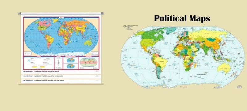
A political map is a type of map that focuses on human-made boundaries rather than natural features. These maps show countries, states, cities, and other administrative divisions. Unlike physical maps, which highlight mountains, rivers, and forests, political maps emphasize political and administrative organization.
Political maps are widely used for education, travel planning, and understanding geopolitical relationships. They provide a clear picture of how land is divided and managed by governments.
Key Features of a Political Map
Political maps contain several important elements that make them useful and easy to read:
Boundaries
Political maps display borders between countries, states, provinces, counties, and cities. These boundaries are created through human agreements and are often marked with bold lines or vibrant colors for easy recognition.
Cities and Towns
Major cities, towns, and capitals are labeled on political maps. Capital cities are usually marked with a star, while smaller cities appear as dots or circles. This helps users locate important population centers quickly.
Human-Made Features
Many political maps include roads, highways, railways, and other infrastructure. These features make it easier for travelers and planners to navigate a region.
Major Water Features
While political maps focus on boundaries, they often show significant rivers, lakes, and oceans to give context to the geography of the area.
Legend or Key
A legend explains the symbols, colors, and lines used on the map. This ensures that anyone can interpret the information correctly without confusion.
Political Map vs Physical Map: Understanding the Difference
A common question is “what is the difference between a physical and political map?” Here’s a clear comparison:
- Political Map: Highlights administrative borders, cities, and population centers. It uses colors to separate countries, states, or regions.
- Physical Map: Focuses on natural features like mountains, plains, rivers, and lakes. Colors often represent different elevations, such as green for lowlands and brown for highlands.
Many maps combine both political and physical features to provide a comprehensive overview. This hybrid approach allows users to see both human-made and natural features in a single view.
What Is a Political Map Used For?
Political maps have many practical uses, including:
- Education: They help students learn about countries, states, capitals, and regions.
- Travel Planning: Travelers can understand administrative boundaries and locate cities or transportation hubs.
- Geopolitical Analysis: Governments, analysts, and researchers use political maps to study territorial disputes, population distribution, and international relations.
- Daily Reference: Many people use political maps for general knowledge, helping them stay informed about the world.
Understanding what is a political map used for highlights its importance beyond classrooms and textbooks. It is a tool that helps people navigate and comprehend human organization across the globe.
Examples of Political Maps
Some popular types of political maps include:
- World Political Maps: Show all countries and major cities across the globe.
- State or Regional Maps: Focus on a single country or state with its internal divisions.
- City Maps: Highlight neighborhoods, streets, and administrative zones within a city.
Each type serves a specific purpose, making it easier for users to understand political boundaries and human settlements.
Why Political Maps Matter
Political maps are more than just educational tools, they are a reflection of human organization. They help us:
- Understand how countries and states are structured.
- Identify capital cities and major urban areas.
- Plan travel routes and logistics efficiently.
- Analyze global and regional political situations.
By studying political maps, we gain insight into how humans shape the world and interact with their environment.
Quick Summary
- A political map shows human-made boundaries and cities.
- It emphasizes administrative divisions rather than natural geography.
- Political maps are used for education, travel, and geopolitical understanding.
- Comparing a political map vs physical map highlights the difference between human-made and natural features.
To delve deeper into the celestial events of September 2025, including the full Corn Moon and its accompanying lunar eclipse, explore our detailed guide here.
FAQs
Q. What is a political map?
A political map is a type of map that shows human-made boundaries, such as countries, states, cities, and capitals, rather than natural features. It is used for education, travel planning, and understanding geopolitical divisions.
Q. What is the difference between a political and a physical map?
A political map highlights administrative borders, cities, and population centers, while a physical map focuses on natural features like mountains, rivers, plains, and lakes. Colors are used differently: political maps separate regions, and physical maps indicate elevation.
Q. What is a political map used for?
Political maps are used for learning geography, planning travel routes, studying international relations, and understanding how countries, states, and cities are organized. They provide a clear view of human settlements and borders.
Q. Can a map show both political and physical features?
Yes. Many maps combine political and physical features to provide a comprehensive view, showing both human-made boundaries and natural geographic features like rivers and mountains in one map.